
UNITED NATIONS | The US Said No to the Equal Earth Map. The Reason Was Not Cartography.
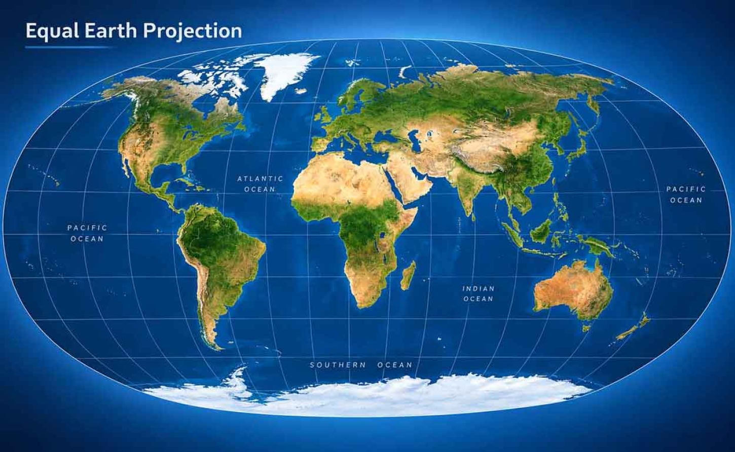
UNITED NATIONS | The US Said No to the Equal Earth Map. The Reason Was Not Cartography.
Washington cast the single vote against, and said why: the resolution carried reparations and “cognitive justice” into a question about map projections. That objection deserves to be heard properly before it is answered — and the region’s stake in the answer is larger than these islands look on any projection.
MONTEGO BAY, Jamaica | Calvin G Brown | Sept. 7, 2026 - On Friday 4 September, the United Nations General Assembly adopted the “Correct the Map” resolution by 164 votes to one. Six states abstained: Estonia, Georgia, Lithuania, Moldova, Serbia and Ukraine. The single vote against belonged to the United States. The text was tabled by Togo on behalf of the African Group and carried the endorsement of the African Union’s 54 member states. Among the sponsors, according to CNN’s account of the vote, was the Bahamas.
What the Assembly actually did
Begin with what the resolution is not, because the shorthand now circling the wires — the UN adopts a new world map — is wrong in a way that matters. The Assembly adopted no map. It passed a non-binding text encouraging governments, schools, international institutions and technology companies to prefer equal-area projections such as Equal Earth, designed in 2018 by cartographers Bojan Šavrič, Tom Patterson and Bernhard Jenny.
No border moves. No maritime zone shifts. That is worth saying plainly in a region where maritime boundaries are not a question of graphic design but the substance of sovereignty, and of the fisheries and hydrocarbons inside it.
Mercator is not banned and will not disappear; it remains the correct instrument for navigation, and it will remain beneath most web mapping at street zoom, where its angle-preserving mathematics is precisely what is wanted.
What changes is the default at the scale where the distortion actually misleads: the wall of a classroom, the graphic behind a newsreader, the cover of a development report.
Mercator does not shrink the Caribbean. It inflates everything above us.
The American case, heard properly
Yaryna Ferencevych, a United States representative at the UN, told the Assembly that the resolution mocked its work and purpose. In her explanation of vote she said the body was debating “map projects from the 16th Century” rather than peace and prosperity, and objected to the resolution’s invocation of reparations and cognitive justice.
Strip away the tone and there is an argument underneath, and it is not the one being caricatured across the region this weekend. Washington is not disputing arithmetic. Nobody in the chamber contests that Africa holds fourteen Greenlands.
The objection is that a recommendation about geometry arrived carrying normative cargo — reparations, cognitive justice, memorial repair — that was never separately negotiated, and that the General Assembly’s authority thins each time it legislates on perception rather than on conduct.
The position is at least consistent: in March the United States objected to the resolution declaring the transatlantic slave trade the gravest crime against humanity. A state entitled to believe the Assembly’s agenda has drifted is entitled to say so, and 164 votes do not by themselves make a proposition true.
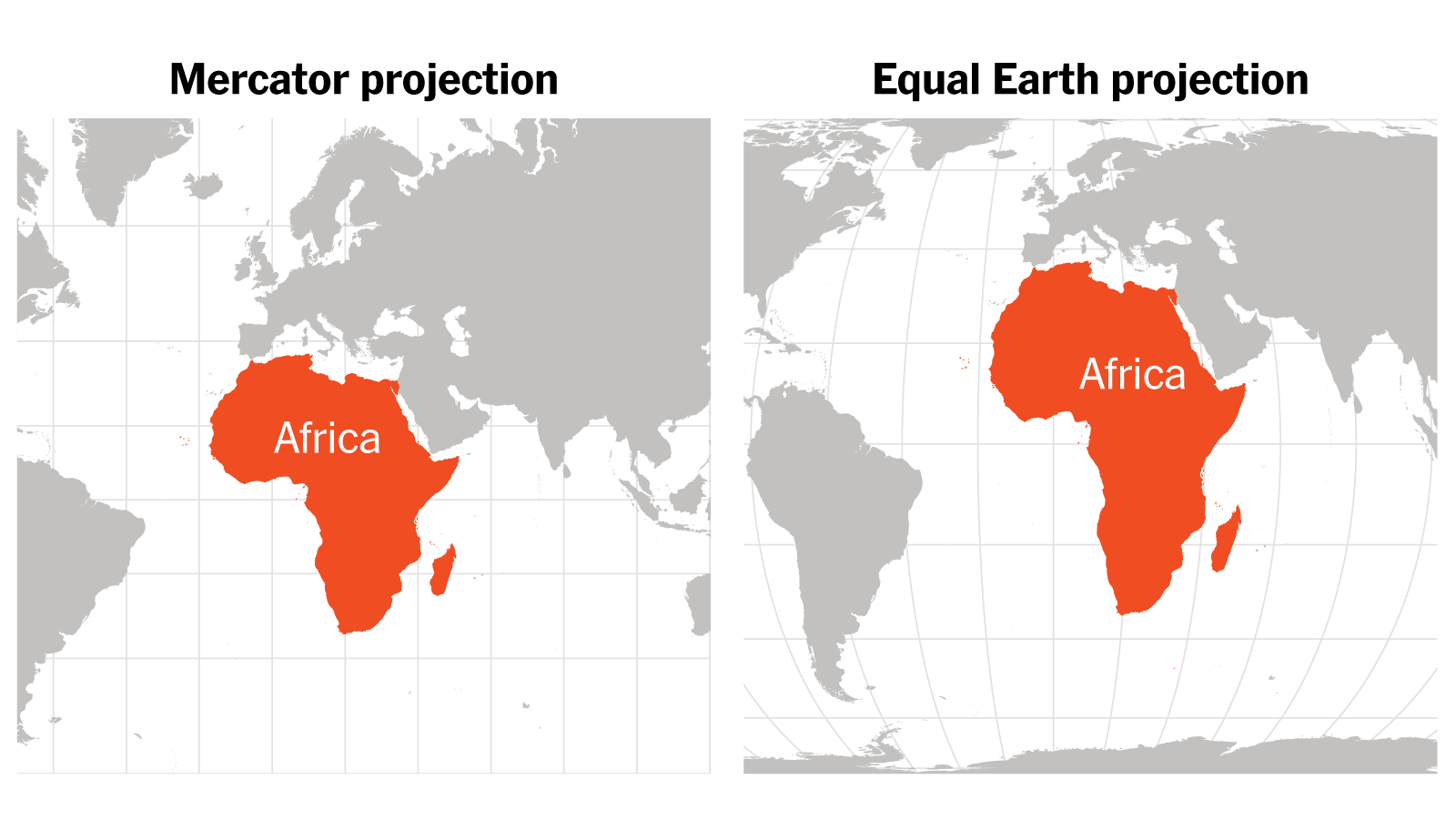
equal earth map
There is an awkwardness, too. Tom Patterson, who co-designed Equal Earth, spent his career as a senior cartographer with the United States National Park Service. Washington cast its solitary vote against a projection its own public service helped to build.
It is worth putting the numbers on the table, because a theory has begun circulating that the American objection is really proprietary — that no country cares to see its own landmass reduced beside Africa’s. Africa covers 30.37 million square kilometres.
The United States, all fifty states, covers 9.83 million; the contiguous lower 48 cover 8.08 million. Africa is 3.1 times the whole of the United States and 3.8 times the lower 48. Stack the lower 48 inside Africa three times and roughly six million square kilometres remain — more land than the entire European Union.
On Mercator that second gap is drawn as around two and a half times rather than nearly four, because the lower 48 sit near 39 degrees north and are inflated by about two-thirds, while Africa straddles the equator and is barely inflated at all.
But if protecting a flattering outline were the motive, Washington would be an odd capital to lead the objection and a lonelier one still. Mercator’s largest beneficiaries lie much further north. Russia, Canada, Norway, Sweden, Finland and Denmark each stand to lose considerably more drawn area under an equal-area projection than the United States does, and every one of them voted in favour.
The American case was made in the chamber, on the record, and it was about reparations language and the Assembly’s agenda. It deserves to be answered on those terms rather than replaced with a motive nobody has evidenced.
Why a non-binding line matters here
The mechanism deserves stating precisely, because the popular version has it backwards. Mercator does not shrink the Caribbean. It inflates everything above us. Scale on a Mercator chart is truest at the equator and swells towards the poles, so an archipelago at fifteen degrees north is rendered more or less honestly and then set beside a Europe and a North America that are not. The islands are not made smaller. Everyone else is made larger, which on a classroom wall produces the identical result.
That is the argument the Caribbean Community’s Reparations Commission has been making for more than a year. Its vice chair, Dorbrene O’Marde, endorsed Equal Earth as a rejection of what he described as the Mercator projection’s ideology of power and dominance, placing cartography on the same rails as the region’s reparations claim. Which is precisely the linkage Washington objected to. Both sides of this dispute agree entirely about what a map is for. They disagree about whether that is a reason to change one.
France moved the other way. Foreign Minister Jean-Noël Barrot, announcing that his ministry would abandon Mercator, said that correcting a representation which distorts the world is already an act of truth.
The part that has not been reported
The domestic question remains open. No Jamaican ministry has yet stated which projection appears in National Standards Curriculum materials, and no CARICOM Secretariat statement has followed Friday’s vote. Neither absence has been explained.
Until those answers arrive, the resolution is a sentence in a United Nations record. Whether it becomes a map on a wall in Hopewell is a decision that will be taken here, by people who were not in New York.
— 30 —
